The Banstead Image Library
Water treatment works


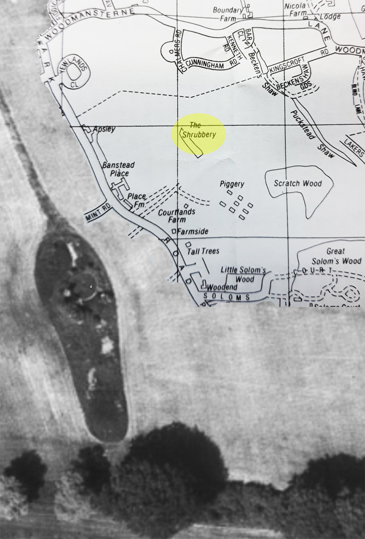
What happened to this water treatment works in Woodmansterne?
See next comment for more details.
Picture added on 19 November 2022 at 12:48
This picture is in the following groups
No Group allocated
No Group allocated
External Links
Banstead History
Banstead History
I can vividly remember the sewer run off from the sewer beds forming a mass of stinging nettles peppered with tomato plants as a result of the seeds passing through the process of purifying the water. Most of my generation who lived in the area would be familiar with the sewer beds as the public footpath ran close to the beds.
Added by Peter Wells on 15 August 2023
Don't remember the water treatment works, but I do recall exploring the eight buried bunkers of Banstead Ammunition Depot adjoining Courtlands Farm, off Park Road, back in the 1960's.
I used to approach it across the fields from the juction of Lakers Rise / Chipstead Way, skirting Scratch Wood.
maps.nls.uk/geo/explore/#zoom=17.9&lat=51.31761&lon=-0.18376&layers=173&b=1&o=100
One thing that fascinated me from that era was the numbers of dumped cars dotted around its concrete roads, a by product of the introduction of the 5 year MOT Test !
This article makes interesting reading too, courtesy of ExploringSurreyPast...
www.exploringsurreyspast.org.uk/collections/getrecord/SHHER_5964
I used to approach it across the fields from the juction of Lakers Rise / Chipstead Way, skirting Scratch Wood.
maps.nls.uk/geo/explore/#zoom=17.9&lat=51.31761&lon=-0.18376&layers=173&b=1&o=100
One thing that fascinated me from that era was the numbers of dumped cars dotted around its concrete roads, a by product of the introduction of the 5 year MOT Test !
This article makes interesting reading too, courtesy of ExploringSurreyPast...
www.exploringsurreyspast.org.uk/collections/getrecord/SHHER_5964
Added by David Isted on 18 September 2024
I have finally found the water treatment works on a 1959 Foul Water map obtained from Thames Water.
The works are marked as Sewage Disposal Plant Demolished, with the sewer rerouted to join Lakers Rise sewage pipes. The sewage works were originally connected to the sewers from Cunningham, Chalmers and Kenneth roads.
The works are marked as Sewage Disposal Plant Demolished, with the sewer rerouted to join Lakers Rise sewage pipes. The sewage works were originally connected to the sewers from Cunningham, Chalmers and Kenneth roads.
Added by Janice Chapple on 19 September 2024
Top left of the map,halfway between Boundary Farm and Nicola Farm, in Woodmansterne Lane, there was a style and a track leading to an old cottage c1650 that backed onto woodlands.
Mr & Mrs Byford lived there, renting the premises from the Surrey Council. They both died around 1955, and the cottage became uninhabited.
In 1957, I endeavoured to buy it! Last year I tried to establish if it still existed, just curious for sentimental reasons, but no luck. Nicola Farm had been developed into houses and the google aerial map did not show any remaining evidence of the said building. Does anyone remember that cottage or what happened to it?
I do recall coming across a sewage works when about 12 years old..."Ugh" kept well clear of the smell. It was in the area indicated.
Mr & Mrs Byford lived there, renting the premises from the Surrey Council. They both died around 1955, and the cottage became uninhabited.
In 1957, I endeavoured to buy it! Last year I tried to establish if it still existed, just curious for sentimental reasons, but no luck. Nicola Farm had been developed into houses and the google aerial map did not show any remaining evidence of the said building. Does anyone remember that cottage or what happened to it?
I do recall coming across a sewage works when about 12 years old..."Ugh" kept well clear of the smell. It was in the area indicated.
Added by John Drake on 25 February 2026
Sheep Farm Cottage was still on the electoral register until 1957, then no sign of it.
There is now a bungalow called The Old Farmhouse which is reached by a track past Nicola Farm which may have been built on the original cottages foot print.
There is now a bungalow called The Old Farmhouse which is reached by a track past Nicola Farm which may have been built on the original cottages foot print.
Added by JaniceChapple on 26 February 2026
The Piggery that is marked on this map is the old ammunition dump. It was our playground as children
Added by Mark Beckenham on 03 June 2026
It certainly was, and mine too.
Added by Janice Chapple on 03 June 2026
I do possess an old map from NLS which shows similar.
Also shows Chambers Cottages, where my grandad was born, in the location of the waterworks. Not as clear as this one
Also shows Chambers Cottages, where my grandad was born, in the location of the waterworks. Not as clear as this one
Added by Mark Beckenham on 03 June 2026
@John Drake the only footpath I am aware of is further up the lane by Hengest Farm.
Added by Mark Beckenham on 03 June 2026
Woodmansterne


It was still in use in the 1950s when my Dad and I used to go bird watching there as it was an excellent haven for insects. We saw our first collared dove there.
I think the plant was run by a generator as there was a low pitched hum which turned the revolving mechanism which dripped water onto the stony base. Does anyone else remember it? Does anyone have any information as to when it was put there and when it went. Thank you.